Our series of self-guided walks continues with the fire-sign of Libra (Sept. 22-October 21 approx.)
You will need the Ordnance Survey 1:25000 South Pennines map. Please note that routes and their condition were accurate at their time of survey, 2017-2020; updates may be made at later dates.
Please be alert to any other quasi-affirmations and correspondences of Libra as you walk!
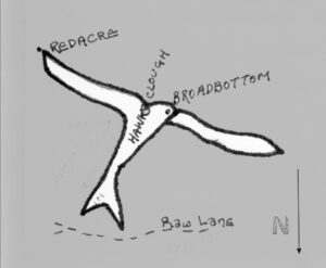
Libra is poised just slightly inside from the ellipse of the zodiac, and is slightly smaller than the other signs. It appears not as a set of scales, as familiar from popular astrology, but as a bird hovering on the edge of Mytholmroyd. This more naturalistic option is entirely in keeping with other examples of terrestrial zodiacs in Britain, and as Libra is an air sign, a bird image seems to me an appropriate image.
In some other terrestrial zodiacs the Libra bird is more like a dove, but the bird depicted here is perhaps a more suitable match for the balance implied by the scales symbol. This winged figure is evenly distributed on each side of a stream known as Hawksclough. Not just any hawk: with its wings held straight out to each side of its body, it is clearly hovering, and there is even a ‘shadow’ wing echoing the flick of the wing sometimes needed to maintain the hover.2 This is clearly a kestrel, the only hawk that hovers, and its slim shape, with its head tucked into its body and the forked tail stabilising the body behind, is clearly depicted in the landscape.1 The hawk form is particularly apparent when viewed from the opposite hillside.
At only three-quarters of a mile in length, Libra is the shortest walk in the zodiac, and presents no great difficulty in walking; a couple of hours should suffice.
The simplest way to approach and enter this sign is through the easternmost wing. Westfield Terrace leads off from the A646 between the Fire Station and Burnley Road school. It crosses the canal towards Redacre, and when we reach Redacre Barn we turn left and follow the track between bee hives and allotments into Redacre Wood, and we are on the Libra wing.
Follow the track at the bottom of the wood. The Libra figure is predominantly beech woodland, and even though in its proper season the leaves are beginning to turn, this is surely appropriate for a figure whose colour correspondence is green. The wing is poised above us as we walk along the path, and after a few hundred yards we come to a fork; take the lower route for a more direct access to a tarmac lane, where we turn right and follow it as it describes a hairpin turn across Hawks Clough and up to the cluster of buildings known as Broadbottom Farm. This little shoulder of land is the only settlement location on the sign, and appropriately it demarcates the kestrel’s head. A footpath coming in from the right just beyond the farm gives a pointed aspect that shows the bird is facing west, looking upvalley. It is notable that it is from this point that we get the longest views up and across the valley, which is of course a totally fitting landscape metaphor for the hawk’s gaze. In all the rest of our walk within the sign, our view is largely restricted to the body itself.
Broadbottom Farm in an important building in the valley, as the rather dilapidated middle section is considered a contender for the oldest standing house in the upper Calder valley. The site was first mentioned in records in 1250 and was once a fulling mill; there was also once a private . Internally, it is a late-mediaeval timber-framed house; its external stone casing is thought to have been added in the 16th or 17th century. The surrounding buildings were rebuilt in the 19th century and at other times. A local tradition claims an underground passage connects Broadbottom with Redacre – i.e. the route we have walked – and there was also once a private chapel at the site. A local friend told me in the 1970s that his mother had had a dream in which she found the tunnel, and came out at Broadbottom to see monks wandering about the farm… and it has also acquired the reputation of a haunted house; suffragette Lavinia Saltonstall peeped in through the window of the old section and saw a light form and grow above an old chest.3 Interestingly for our current exercise, the barn conversion was renamed in the early 21st century – to Kestrel Barn.
The path crosses in front of the farm, and a yellow arrow directs us past a hen pen towards the western extension of the woodland, which is also the westernmost wing. Again, the path follows the bottom of the wood. Across the field to the left is another strip of woodland – this is the ‘flicking’ shadow wing that suggests the hovering stance – and we still get, under the hawk’s eye, the long views across and along the valley. Still keeping the wood and wall to the right, we come across stiles, into a field and to another stile at its far corner. The stile is where we leave the wing; its line follows the top of the wood, where there is no public right of way. So we take the uphill path to the right, and shortly come to a junction; we take the right-hand path that climbs round on rudimentary steps to the right of a large beech tree. This path keeps to the wall as it climbs gradually, and at another stile we can see houses beyond; when we reach these, we meet a tarmac lane, and turn right, following signs to Owlers and Stephenson House. The trees of the Libra wing are visible across the field to the right – we are only a little way off the figure.
Keep on past Owlers – a stepped path at the far side of their gardens will lead us back to the hawk at Broadbottom should we choose, but keep on to Stephenson House, and where the tarmac ends just beyond the house and the path splits into two, take the lower one, across a stile and downhill into a field. Note that this path can be muddy, but duckboards carry it across the worst points. At the bottom of the field we cross a stile, and the stream just beyond it; we are back in beech woodland, and back in Libra. Here is the tail, the woodland above marking its forked tail. The path carries round to another stream crossing, a bit trickier than the first, but once we do we’re on the body of the hawk. Each of these streams has marked the edges of the tail.
This path takes you right along the spine, looking down to the right over a steep clear slope to Hawks Clough, composed of the two streams we have just crossed. It’s a bird’s-eye view.
When we reach the wing-pit, where the easternmost wing meets the body, there is a metal gate and a wooden bench. Take the path to the left along the top of the wood and the wing, past another wooden bench and diagonally down the hillside on a broader path, again following the line of the wing, back to Redacre, and out of Libra.
If you’ve more walking in you, you could extend the walk on the far side of the valley. On the far side of the Nest Estate you will find Park Lane, an unsurfaced track across the hillside to Wood Top and Hebden Bridge, from which you can see the Libran hawk shape outlined in the woods opposite.
Notes
- The dove and hawk, however, do share a spiritual connection. Robert Graves notes in The White Goddess that when John the Baptist baptised Jesus, a dove descended to the ‘King of Jews’; and that this should be seen as equivalent to the ka of Ancient Egypt, symbolised in royal coronations by a hawk descending on the new Pharaoh.
- There is a similar image in the Bury St Edmunds Zodiac.
- Valley Life 41, p10.