Our series of self-guided walks continues with the fire-sign of Leo (July 22-August 21 approx.)
You will need the Ordnance Survey 1:25000 South Pennines map. Please note that routes and their condition were accurate at their time of survey, 2017-2020; updates may be made at later dates.
Please be alert to any other quasi-affirmations and correspondences of Leo as you walk!
Leo, for obvious reasons, is typically feline; but in Hebden Bridge’s zodiac it is a cat, depicted at an appropriate size in an affectionate relationship with Virgo. Under Virgo’s caress, the cat arches its back. Its back paws stand on the ancient village of Heptonstall, but its heart lies in Hebden Bridge, and its head in the wooded valley of Nutclough. One forepaw is delicately raised in a typical feline gesture, avoiding wetting itself in Hebden Water. Leo’s innate dynamism is aptly expresses in the way the sign encompasses the industrial history of this part of the Calder Valley, and its busy expansion beyond its narrow goblet-like valley location.

The Walk
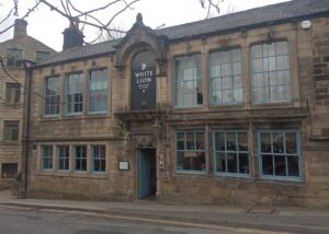
It surely makes sense to start the Leo walk at the White Lion Hotel – not only because it’s a leonine reference, but also because it’s a Yorkshire Leo, hence white like the rose… It is the oldest hostelry in the town; a datestone over the door of the present building reads 1657, but it was in business before that, and was known as King’s Farm – the tenants’ name providing an apt association, given Leo’s association with royalty and leadership. Inside, the building’s star feature is another apt Leonine coincidence, tallying with its Fire element – the considerable 17th-century fireplace, complete with spirals at either side that, symbolising smoke, were held to be protective against fire attacking the building.
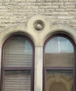
So it is here where the fire of a royal lion is kept in its proper place that we enter Leo, at a point on the cat’s spine – again appropriate, for Leo’s bodily associations are with the spine and heart. We head south, past Bridge Mill on the corner, with its chimney still standing. Opposite the mill is St George Square – note the silver sculpture, because although not immediately obvious, it is another reference to the solar and dynamic nature of the town’s sign. Erected in 2008, the sculpture represents a fustian knife, a symbol of Hebden Bridge’s leading industrial history in fustian products (cloths with soft or velvet-like naps, such as corduroy and moleskin), earning it the nickname Fustianopolis. It is also a gnomon for a sundial inscribed in the flagstones around it. We don’t see the sun often enough in this valley, perhaps, but the gnomon seems to call it in. On the other side of the square, Crown Street echoes the royal sub-text of Leo.
Across St George’s Bridge (1892) between Bridge Mill and the Shoulder of Mutton Inn is the heart of Hebden Bridge, and the heart of Leo. Immediately on the other side of the bridge is the new Town Hall, created from the old Council Offices; opposite is the old market, now a car park – both these places speak to the administration and trading associations of Leo, that are vital to building prosperity. Both old and new fire stations found their place in fire-sign Leo’s heart, too.
Walk past the Shoulder of Mutton down Bridge Gate to the old bridge, that gave the town its name. The stone bridge is thought to date back to around 1510, but of course succeeded at least one earlier wooden structure.
On the other side of these two bridges is a mix of residential and industrial buildings that lie precisely on the cat’s heart region – and not just the heart of Leo, but the ‘heart’ of Hebden Bridge past and present. Beyond the old bridge, the steep setted ancient track known as The Buttress has led travellers and traders down into town from Heptonstall and Lancashire beyond – an artery feeding into the heart of Hebden Bridge in both pre-industrial and industrial times.[1] Look at old photos of Hebden Bridge, and note the smoky mill chimneys scattered all across the Leo area.
Continuing along Bridge Gate, turn right at the main road, and cross the Hebden Water at West End on to Market Street – the whole walk so far has been along the leo cat’s spine as it arches on the north banks of the rivers. Note the Heart Gallery as you pass, converted from Ebenezer Baptist Chapel, built in 1777 – note the datestone above the doorway, and the large sundial on the wall. Between Ebenezer and Heart, it has been a printer’s office, office of the Hebden Bridge Times and an arts centre. The sundial is not the only solar allusion in Market Street; to see more, cross the road at the zebra crossing by the bank, and look over to the shops on the other side of the road – solar radials appear at the upper-storey windows and on either side of the shop fronts. Continue along Market Street, and just past the Co-op look across to Barkers Terrace and the lower end of Hangingroyd Road, where similar symbols appear again at windows. A little further on is the long-established (1991) Kitties Restaurant!
 Solar symbols on Market St. buildings

Cross the road again either by the traffic lights at the Fox and Goose, or at the traffic island 250 yards beyond. From the pub onwards, we are walking along the cat’s tail. The road dips, and if you look about 45o to the left and up, you might see a rock outcrop poking through the leafy trees – this is Cat Scout, looking out over the Hebden Valley. Turn right down Church Lane – note the remains of Bankfoot Mill chimney here near the corner, and a taller one from Mytholm Mill still standing across to the left. We are still in Leo, and the industrial energy has impacted on this area too. This district is Mytholm, and was studded with mills, even silk mills.[2] The King family was active at this end of Leo too – it was James King who started Mytholm Mill in 1789, and nearby King Street, roughly where Adelaide Street is now, opposite the Church Lane junction, recalled the same family.
Continue on Church Lane to the Parish Church of St James – built here in 1833 on donated land, and suitably placed if we take an calendrical approach to the Leo figure. St James’ Day is July 25, shortly after Leo begins July 21 – the church’s location a little distance into Leo is roughly equivalent to the saint’s day position in the calendar.
Beyond the church, take the right fork past the school – there are three schools on or adjacent to the Leo sign (Hebden Royd Primary, Stubbings Infants and Heptonstall old Grammar School), and two very close (Central Street infants and Riverside Junior, formerly County Grammar School). Follow the road a few yards to the bend where a track on the right cat-legs back (when I visited, the public footpath sign was obscured by foliage). Take that, and at the next zig-zag carry straight on towards a driveway gate; just to the right of the gate, the footpath drops down and meanders along the hillside to a junction of paths marked with stone posts. Go straight across, bearing leftwards, with the stretch of stone wall on your left. After about 20 yards, a yellow footpath sign on a wooden path directs you uphill to the left.
This path is marked on the 1850 OS map as ‘The Old Corse Road’. Corse is a dialectal variant of the word corpse, and the OS surveyors were recording a tradition that funeral corteges en route to Heptonstall church from this side of town took this route, tackling the slope at a steady but easier gradient around to Lily Hall before tacking up to the village along the route of the modern road (funerals from Hebden Bridge direction, including that of ‘King’ David Hartley, the Coiner executed in 1770, went up the steep Buttress). Such customary routes were known as corpseways (see John Billingsley, Journeys of the Soul). Note as you climb how well engineered the path is in terms of width, walling and gradient. At a junction of paths, the corpseway continues straight across, but you turn left. Pass a quarry, the first of several along this track that are known generally as Hell Hole quarries – aptly, as having turned off the cat’s tail at the junction we are now In the vicinity of the cat’s anus!
Now there’s a bit of a dilemma, especially for completists. Beyond the quarry, as you emerge into the open, the map records a path climbing off to the left, and this is the path that marks the cat’s rear end. Unfortunately, as far as I can see during the Leo period at least, it is lost amidst the bracken and blooming heather. There are two options, and both involve continuing on this main path for the time being.
The first option is for near-completists, and comes just before you reach the next patch of woodland; a path jags back uphill to the right, and you can follow that to link up with the map line of Leo. Near the top of the slope you’ll see a path coming in from the right, which is the top of the path marking the rear end; should you wish to, you can follow it down to check the route – the clear path takes you around the top of the quarry near the corpseway junction, but halfway down you come to a gatepost, and just to the right there is a hard-to-see step down to the merest vestige of a path emerging from the bracken. Having checked that out, you can climb back up, and rejoin the path you were on as it curves round between stone walls and continues towards Heptonstall Bowling Club car park – the tower of Heptonstall Church is right ahead of you, to ensure you don’t get lost. And that’s Option 1.
Option 2 takes you a bit off the outline of the cat, but I feel ‘near vicinity’ of a sign can still be within the ‘sphere of influence’ of that sign. Moreover, it’s easier, prettier and interesting. For this, you ignore the little path jagging back on the right and keep on the main track towards the wood. You pass the main Hell Hole Quarries – so in a way you are still maintaining the link with the cat’s rear end. In some of the rock outcrops you pass, you will see circular indentations in the rock – these are natural, but in local folklore have been ascribed to cannonballs fired at Heptonstall from Stoodley Pike by Oliver Cromwell’s forces; doubtless by adults stuck for an answer to a child’s question, and not fully aware that in the Civil War in 1643 Heptonstall hosted a garrison from Cromwell’s own side! Anyway, moving on, the path leads to a massive monolith standing separate from the quarry face, and according to 19th-century antiquarians it has a name – Llad Law Balder. This is a curious name, as it comes from different language streams. Llad Law is a Celtic construction, with the double l probably added by antiquarians to arrive at the romantic explanation of ‘the slaughter hill of Balder’. More likely is Lad Law, a Middle English variant rather than an incongruous Celtic outlier that appears on Wadsworth Moor and Boulsworth Hill, but this still has an uncertain meaning. Clearer but more curious is the association with Balder/Baldr, a Norse god known as ‘The Shining One’ and associated with Old English baldor, ‘lord, king’ – which places him as a solar hero and firmly in the Leo domain, if standing here slightly outside it. Even here, the dynamism of Leo is working – these Hell Hole quarries provided the stone for the 19th-century church of St Thomas the Apostle in Heptonstall, which cost £6666 to build – a couple of facts which I find oddly pleasing!
Beyond the monolith, against the rock face, a path leads up steps to the top of the quarry. Climb these, and at the top pass through a gate on the right, to a path leading along the cliff edge. From this path are some of the finest views in the upper Calder valley, and if you follow it through you will come to the Bowling Club car park, where you meet up with Option 1.
At the gate of the car park, turn left along a track that leads along the backs of the houses on the estate, and come to another choice.
Again, if you’re a completist (if not, skip to next paragraph), when you get to tarmac, turn right and right again immediately along Southfield; at the bottom, facing the playing fields, turn left and follow the tarmac road back up along Longfield to the church. Taking this route delineates the hind legs of the Leo cat, which clearly came into being with the building of the council estate – the street names refer to the old mediaeval fields of the village. At the top of Longfield, turn right and just before the ‘restricted zone’ signs pass through a gate on the left and follow the white railing up to the churchyard, and enter.
Those who might prefer not to walk up and down the estate’s roads will ignore the right turn on to Southfield, etc. Your path crosses the tarmac and heads straight for the church. When you get to the churchyard, bear right along West Laithe and you will come to a gate into the churchyard, opposite where the completists emerge from their white-railinged path.
Enter the churchyard – you are now on the paw of one of Leo’s hind legs – and turn right along the bottom of the church into the oldest section. It’s thought that over 100,000 people may have been buried here, not only raising the ground level, but also seeping into the village water supply until the connection was made.
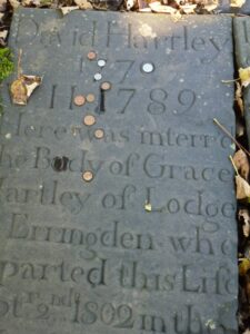 Among the graveslabs is that of the only king known to be buried here in Leo – ‘King’ David Hartley, leader of the Cragg Vale Coiners, a gang of 18th-century counterfeiters who clipped the edges off gold coins to mould into new ones. They were sufficiently organised in depreciating coin to cause a wobble in the national currency, but locally they were often just seen as making limited supplies of gold coins go round a little further. This tale of gold and a gangster ‘king’ is shot through with Leo associations, but surely of its shadow side.
Go into the ruined church, originally dedicated to St Thomas a Becket, a popular saint in the 13th century, when it was built. A massive storm severely damaged the fabric in 1847, resulting in the construction of the new one (itself struck by lightning, i.e. a firestorm, in 1875, knocking a pinnacle off the tower), but the skeleton of the architectural collage of the old church was kept. Violent storms are the classic weather type of Leo, and neither storm nor fire are strangers to Heptonstall – a Civil War battle on the slopes below the village in November 1643 routed an attack by the Halifax Royalist garrison, who returned for vengeance early the next year and burned down 14 houses.
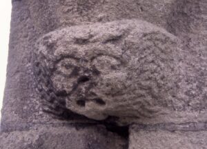
There is only one carving inside the old church – facing the altar, head over to the left-most aisle, and on a level with the altar you will see a grotesque carved on a corbel about 4ft off the ground. This is Awd Sal, and a close look will reveal that she is a lion, with typical cat ears and a flowing mane, and a less than typical protruding tongue. Further up this aisle, following the 1847 storm a curious object was found, possibly fallen from the rafters; a mummified cat. This is a relic from a folk-magic belief that the spirit of a cat immured in a building would protect that building’s luck. Its patience obviously ran out in 1847. It was acquired by the Cross Inn and exhibited there for some time, but its current whereabouts are unknown.
Exiting the ruin, take a look at the unusually informative information board at the foot of the churchyard if you’d like to know more about the old church, and exit through the gate. The building on the right is the old Heptonstall Grammar School, founded in 1642 and active until 1889; in 1898 it was taken over by the Yorkshire Penny Bank (later the Yorkshire Bank), who took pains to preserve some of the original furniture and features. Now it’s the home of Heptonstall Museum, open at weekends through the holiday season – among its exhibits are the equipment used by King David’s Coiners.
Leave the little enclave by the archway; the building on the left is Heptonstall’s old Cloth Hall (see the plaque on the wall). It is one of three buildings in the village that were named after famous buildings in London – this, Blackwell Hall; Star Chamber; and Whitehall – which might indicate a level of Leonine hubris in village history! Where the alley meets the road, look right, and see another White Lion inn, bookending the Leonine hotel where we the walk began.
Turn right and descend the setted street, following the line of the cat’s hind leg. Follow it downhill on to tarmac, round a bend, and about 200 yards beyond the bend, opposite a gateway in the wall on the other side of the road, take the footpath down steps to the left, and follow it down to the road. Turn right, and just past the speed limit signs turn sharp left at Lee Mount. Follow the path straight past a three-storey building, and take the right-hand path when it forks. You are now following the cat’s underside and lower ribcage, but please note that the stone paving on this stretch of the path is often slippery – take care, and where a handrail is provided, you might choose to use it. Eventually you arrive at Salem Field, home of a cricket club and an archery club – their grounds delineate one front leg and paw of Leo. Cross the old bridge here and you are back in the body of Leo, back to an area historically of industrial buildings, but now largely given over to residential. At the end of this road, turn sharp left into Windsor Road, and climb to the very top, where you’ll find a small path leading up; alternatively you can climb the stony track just before the top of the road. Either way, you will get to a small lane.
To the left, Leo’s other foreleg continues, but marked as a precipitous wooded slope. If you look over the wall, at the foot you will see a path running beside a mill goit, marking the other side of the foreleg. You can circumambulate some of this, but very circuitously. So instead, when you reach the lane, turn right and walk to the main Keighley road at the turreted Old Co-op. Turn right and walk down the road till you get to a bus stop at the top of Lees Road – play with the similarity of the Lees placenames in this vicinity with Leo for a while, if you wish, but the usual meaning of ‘lee’ is field or sheltered place – and cross the road. Some steps beside the row of houses take you up into a wood, and a bit of a steep slog to Hurst Road, above. This is the neck and lower and lower snout of the cat. Turn right, following the line of the head, and come to the terrace known as Stoodley View; at the far end is Hurst Royd, and above the windows appear again the solar symbols seen along Market Street. The road turns into a path downhill to a lovely bridge crossing the upper reaches of Nutclough.
This is an important point, both in terms of Leo and of the landscape. The valley suddenly deepens here, from a relatively level stretch to a narrow deep one; the stream suddenly becomes a dynamic force, cutting a cleft through the wood, sprinkled with waterfalls – from relatively calm to dynamic. The bridge is built up with stonework to accommodate this change – and in the centre below the arch there is a lip in the stone footings through which the stream pours. The spot is in its own way quite dramatic.

This bridge is also where Leo conjoins Virgo; the female Virgo figure caresses the cat’s head (is the cat her familiar?), and in the position of her hands it is as if she is not just stroking, but giving a libation of water to the Leo cat, pouring through the lip under the bridge into Leo’s head, where it is transmuted. The image links the phases of Hebden Bridge’s industrial history – from the water power that fed the Colden valley’s early mills to the further development of the town’s textile industry through innovation, fire and steam – from natural energies to those created by the human drive for progress so amply represented by Leo.
The Tarot trump associated with Leo is ‘La Force’ or ‘Strength’ – the 16th-century Marseilles and early 20th-century Rider-Waite packs depict a scene highly reminiscent of the Virgo-Leo conjunction here: a woman holding a lion by its jaws. The message is the strength that can be derived from the controlled use of power – again, a highly apt metaphor for Hebden Bridge’s development.
From the bridge, follow the track around to the white house, and join the tarmac road towards the town. At the junction with Birchcliffe Road, cross over and take the ginnel beside the post box downhill. But again, this is a steep setted track, and under certain conditions is very slippery; there is a handrail, but you might prefer to take Marlborough Road, opposite where you emerged at the junction. At the foot of the slope is the last of Leo’s schools, and to the right of the ginnel the site of St John’s Church – opened 1929, closed 1984 and now only a place-name for new-build houses. Cross the road, and take the setted ramp down to the Keighley Road below – and the White Lion where you started.
[1] An 1869 oil painting of Hebden Bridge by John Holland shows the developing ‘heartland’ of Hebden Bridge; reproduced in Fustianopolis – Hebden Bridge: The growth of a textile town, Hebden Bridge Alternative Technology Centre 2011, p.4-5. Recommended for its succinct description of the town’s industrial development
[2] Recommended for information and maps are Power in the Landscape (Alternative Technology Centre 2007) and the excellent website on the project, containing history, images and maps: http://www.powerinthelandscape.co.uk/about/index.html