A small stone circle sits on a low hill in Okayama, Japan, at the hub of a remarkable sacred landscape featuring alignments, stone groupings and megalithic architecture, and narrativised by local legends.
This article was prepared by John Billingsley in 1991 for a book on international landscape mysteries that to the best of our knowledge never appeared. Our apologies for the rather ‘handmade’ quality of the illustrations…
Once, magical tradition decreed that power over a populace was facilitated by control of certain numinous places within a landscape. The reasoning was not merely pragmatic; the Earth was thought to have energies that could be better accessed at such places than others, and the nature of the land expressed through them affected the character of the people. ‘Taming’ these natural shrines could tame the people who lived under their influence.
At first sight, Tatetsuki, in Japan’s Okayama Prefecture, is simply a stone circle, a rarity among ancient monuments (but not that ancient). Its bizarre stones remind one of western-style furniture, and stand on a 15ft high mound on top of a low hill overlooking the coastal plains. On further investigation, however, Tatetsuki’s mystery deepends.
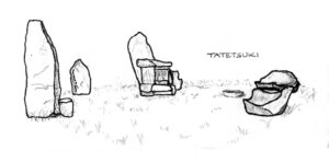
The only datable items found at the circle are two burials from around the 3rd century CE. Although one of these burials was very plain, the other was ritually elaborate, with a red-ochre floor and an overlay of clay dolls for the body. Grave goods included an iron sword and the comma-shaped magatama beads that are ubiquitous in Japanese votive contexts. The circle itself had other intimations of being a ritual centre; it had pebble paving, a drainage system and a stone avenue leading away from it. There is even a suggestion that the stones themselves were coloured red. There are seven stones – six on the perimeter, and one at the centre.
It was local historian Hideo Kurozumi who found that Tatetsuki stands on two major alignments. One is an E-W corridor of sacred sites connecting the far west of Japan with the Nara region, centre of the ancient Yamato capitals. This line’s orientation towards equinoctial sunrise reveals its solar association, and was called by Kurozumi The Way of the Sun.[1] The other alignment is local to Kibi, as this area was known at the time. The stone circle stands at the junction of the two, linking local and pan-cultural geomancies.
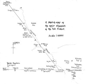
We are fortunate that local folklore has developed around these alignments, and tells of a warrior from the Yamato court, Kibitsuhiko, and Ura, a local potentate described as an oni or ogre. Ura’s forces were based at the ancient hilltop castle of Kinojo; Kibitsuhiko took his stand at Tatetsuki, about 6mls away, and loosed arrows from there. Ura replied with great stones which struck the arrows in mid-air, and are still to be seen along the alignment. Defeat ensued when when Kibitsuhiko fired two arrows at once, one of which evaded Ura’s stone and lodged in his eye. The blood flowed, colouring the waters of Chisuigawa (blood-absorbing river) at the foot of the mountain. Seekeing escape, Ura turned himself into a carp and swam off down the river, but was caught by the equally magical Kibitsuhiko in cormorant form, and eaten where the shrine known as Koikui-jinja (carp-eating shrine) now stands.
It can be seen from the map how this take ties in with the alignments, and other stories of Ura and his wife, Aso-hime, add more background to this geomantic episode.[2] Kibitsuhiko represents the court of the Sun Goddess Amaterasu in the Nara Plain, at the end of the solar line; Ura, the stone-wielding giant of the interior mountains, is surely one of the ‘unruly earth deities’ spoken of in Japan’s ancient chronicles. The power struggle is therefore of a sacred as well as political nature.
One of the burials at Tatetsuki suggests, with its grave goods, a character embodying both secular and sacred power. Whether this might be Kibitsuhiko is pure speculation, and need not detain us here, for more important by far is a stone unearthed near the centre of the circle. A wavy ‘binding’ pattern, similar to the chokkomon broken-spiral pattern found elsewhere in tombs and on artefacts,[3] covers the stone, with a clasp-like boss protruding at the front. What might this design mean? It is reminiscent of ‘binding’ patterns of omphaloi stones at Delphi in Greece and Turoe in Ireland,[4] and may indicate that this stone too is an omphalos or shizume-ishi (Calming stone).
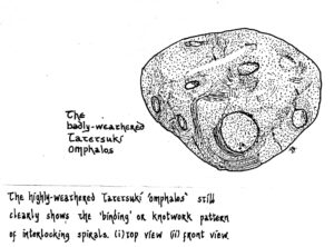

The omphalos is the ‘navel’ or centre of the world, the focus of the earth’s energies, at a local or larger scale; a ‘binding’ ritual, as symbolised by stones such as these, imposes order upon an unruly place, and the stone’s placement at the omphalos radiates its effect over the geomantic hinterland. Oral tradition and archaeological findings support the suggestion that Tatetsuki is the omphalos or sacred centre of old Kibi, inevitably attracting the attention of the Yamato clan as they and their tutelary goddess sought to unify the entire country under their rule. The stone is the magical counterpart of the Yamato governors.
Recognition of Tatetsuki’s importance as a historic site came in the late 1980s. The stone was classified as an Important Cultural Property, although not expressly for its geomantic significance, and was removed from the centre of the circle, where it had been housed in a cabinet, to a windowless concrete hut outside the stones. Nonetheless, Tatetsuki maintains its aura of ritual and mystery, and its key role in the surrounding landscape of significant stones and shrines.
![]()
Hideo Kurozumi, Akiko Kuroda and John Billingsley at Itsukushima shrine in Kibi, March 20 1983
Notes
1 [added 2020: Yumi Wijers-hasegawa, ‘Flaky or Fact? Are ‘power spots wacky … or what?’, Japan Times 18-3-07 https://www.japantimes.co.jp/life/2007/03/18/to-be-sorted/flaky-or-fact-are-power-spots-wacky-or-what/, acc’d 4-7-20, notes a website by Kazunari Uchida, ‘Leyline Hunting’ http://www.ley-line.net/index.html (acc’d 4-7-20); Uchida refers to another Taiyo no Michi connecting Hasedera, Kunitsujinja & Mt Miwa; also Goraiku no Michi (Way of First Morning Sunlight) connecting Kazusa Ichinomiya (Chiba), Samukawajinja (Kanagawa), Mt Fuji summit, Chikubushima (Lake Biwa), Izumo Taisha (Shimane).
2 J. Billingsley & A Kuroda, ‘Return to Tatetsuki’, The Ley Hunter 103, Sporing 1987; J Billingsley, ‘Lines & Legends: Memories of Geomancy’, Kyoto Journal 5, p32-36
3 J Billingsley, ‘Chokkomon: Spirals with a riddle’, Caerdroia 1983 and https://northernearth.co.uk/chokkomon-japans-fragmented-spirals/
4 See Nigel Pennick, The Ancient Art of Geomancy, Thames & Hudson 1979, pp.44-45