Our series of self-guided walks continues with Taurus (Apr. 22-May.21 approx.).
You will need the Ordnance Survey 1:25000 South Pennines map. Please note that routes and their condition were accurate at their time of survey, 2018-2020; updates may be made at later dates.
Please be alert to any other Taurean quasi-affirmations as you walk!
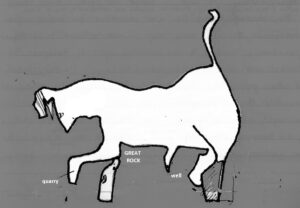
THE FIGURE
Most of the Taurus bull’s outline is composed of public rights of way, but embellished where required by field boundaries and streams. The bull is somehow upside-down, with his hooves on the heights and his head and waving tail on the lower levels of the landscape. One foreleg is raised in an aggressive stamp, echoed by the lowering of the head; the bull may even be preparing to charge, facing off against the Gemini giant on the other side of Jumble Hole Clough. The hindquarters are solidly Taurean, massive, strong and mobile, and the virility of the beast is emphasised by a prominent penis. The whole figure is similar in size to Aries, at about a mile in length.
Unsurprisingly, this part of the zodiac is largely given over to cattle farming, especially in its hindquarters. The valley’s only cheese producer is also within Taurus, at Pex Tenements.
OVERVIEW
It is highly advisable to carry a copy of the OS South Pennines Explorer map with you on this walk; in some parts, footpath signs and the yellow arrow markers are few and far between even on rights of way.
The best time to walk Taurus is indeed in the time of its zodiac sign, for it is then that the well-tended gardens of several of the homesteads here are coming into bloom, demonstrating the Taurean affection for beauty in the home environment. Look for the Taurean colours of blue, pink and green not just in these gardens but also in the wild flora, particularly in the wealth of bluebells in the Taurean woodlands at the eastern and western fringes of the sign. The lush new grass of the fields around Great House and Upper Eastwood is good fodder for the cattle and new calves that are part of the large-scale dairy farming on this sign. As you look out and around you, there is little sense of towns on this plateau above the valley; for me, the earth – Taurus’ own element – feels stronger here than anywhere else in the valley.
Another thing to look for on this walk is the solid vernacular architecture of the scattered farms, with a number of 17th-century datestones indicating that they were among the earliest of the acclaimed yeoman houses for which the Halifax area is famed[2]. Financed by a dual occupation economy – farming and textiles – these are not gentry houses, but the improved homes of yeomen.
Non-conformism was strong in this area and festivity and dancing were frowned upon more strongly than in other townships of the valley. Both bygone and modern Taurus is largely a backwater in the nicest sense – though criss-crossed by old paths between the farms, linking participants in the pre-industrial cottage-industry phase of the local textile trade, the main wool routes bypassed it, and the one mill in the area, at Upper Eastwood, is gone. Here in Taurus, people get on with things in peace, and that is doubtless how the Taurean landscape likes it.
THE WALK
Our walk begins at the foot of Jumble Hole Clough, and we take a path along the top of Spring Wood on the line of the horns, zigzagging back on ourselves to join the head at the top of the bank. Along this track on our left is a small enclosure with a circular section at one side. A sharp left turn shortly beyond here along the track towards Hipperholme brings us along the line of the lower neck – it is the neck over which Taurus has rulership, and we take a path which traverses the neck and shoulders past Upper House Farm towards the hamlet of Upper Eastwood.
Among this collection of buildings is Eastwood Hall, seat of the Eastwood family. Although the datestone is of 1630, the site is older than that, and so is the family, which, if one account is to be accepted, has itself a remarkably Taurean character. Newell wrote that “although the family to which has become attached the local territorial signification is one of the oldest of local clans, very probably the one which has remained the longest attached to one spot, it would seem that on the whole its members have pursued an even, uneventful course through the centuries, seldome interfering in affairs outside their own locality. Apparently they have been men of strong convictions, conservative in instinct, with a facility for adapting themselves to the changes which time and circumstances wrought around them, and generally ready to oblige their neighboyurs.The success which several individuals of the later generations have acquired in the profession of the law would seem to suggest that in that realm lies the true vent for their peculiar mental capacities…”[3]
Following the road past Upper East Lee, which marks the back of the bull, we turn back upon ourselves where the road turns left at Lower East Lee (datestone 1631); the path which continues the line of the road crosses Ingham Clough, which is the steep gully down to the valley bottom that forms the upraised tail of the testy bull. Keeping within the figure, however, we head across the fields towards Mount Pleasant at the top of New Road, which marks the thigh of the bull’s left hindleg. New Road takes us to the cattle farm of Great House, beyond which we turn left on to the tarmac road and follow it up to a track which leads to the right at Stansfield Villa. The track, Butts Lane, is the rear of the left hindleg, and where it becomes a deep path a stile appears on the right; this path marks the hoof, and we follow it to Birks Clough. The stream draws the front of the hindleg back towards Great House, but we can carry on along the path to the other hindleg, passing Higher Birks and heading for the motor road beyond. There, we could turn right, keeping to the line of the leg back down towards Great House, and following the underside of the bull across the fields from there; but we will take a short cut by turning left and walking up the road.
We soon come to Ballingroyd (or Bollingroyd) Farm, one of the most aptly-named places in the landscape. Apart from the pun on the word ‘bull’ implicit within the farm’s name, it also stands at the tip of the Taurean phallus, adding yet another pun! Behind the house is a long, thin and pointed field or garden, which represents the penis; in the lane beside it, near the tip of the penis, stands a well! It is curious that ‘coincidence’ creates here a cluster of earthy landscape puns that draw attention to the typical virility of the bull and the Taurean character.
At the base of the penis stands another old house, Lower Birks, whose datestone is inscribed 1661. Its window mouldings at the front have an unusual but significant design on their terminals. Whereas many local houses have carved heads in this position, which were thought to protect the house and tenants from misfortune, Lower Birks has wheel symbols. This is another evil-averting device, occasionally found in England, but strongest in the weaving and farming communities of the Nettherlands.
Returning to the back of the house, we now take the path heading east behind the buildings. Grey Stones Farm (1672) is in the dip below us, and we come to a meeting of tracks. The wide track downhill to the right marks the upper thigh of the left foreleg, but we turn left uphill until we come to the tarmac road.
Opposite us, close to the knee of the great bull, stands the massive outcrop of Millstone Grit known as Great Rock or Devil’s Rock. For centuries, this has been a place for lovers’ trysts and jaunts, and graffiti in a wide variety of styles adorns the surface of the rock. What must take our attention primarily, however, are petroglyphic markings on a shelf on the uphill side of the Rock. There seems to be a figure of a bull, about three feet long, scratched out in the rock – it is sketchy, in a style highly reminiscent of the Uffington White Horse, but the general impression, despite an overlay of graffiti, is clear. Moreover, above it, on the side of the Rock, is another petroglyph, apparently depicting a bull’s head and horns! Who created these, and when? And did he or she know of the bull in the landscape in this area?


Such a site cannot be without its legend, we think, and indeed the name Devil’s Rock comes from a tale that God and the Devil had a wager in this part of the valley; if the Devil could step from Stoodley Pike to the Rock, he could have the souls of the valley. Old Nick nearly did it, too; he landed on the Rock, but his cloven hoof split the stone, and he lost his footing – and the valley has never surely been that far from sinful unChristian ways since!

The motor road turns the corner and passes Staups Dam at the bull’s knee, but we branch off to the right at the bend and cross the stamping right foreleg. To our left are quarries covering the lower leg, and another rock outcrop stands at the knee. We turn right where our path meets a cross-path, and this will take us up the bull’s front to the neck, where we tiurn left and walk back, retracing our steps along the head and horns of the bull to Jumble Hole Clough and the main Calder valley.
[1] Jessica Lofthouse, Lancashire’s Fair Face
[2] Colum Giles, Rural Housing of West Yorkshire
[3] A. Newell, ‘Eastwood & the Eastwood Family’, HAS Trans. 1916, p.145-168, p.147