Our series of self-guided walks continues with Pisces (Feb. 22-March 21 approx.).
You will need the Ordnance Survey 1:25000 South Pennines map. Please note that routes and their condition were accurate at their time of survey, 2018-2020; updates may be made at later dates.
Please be alert to any other quasi-affirmations of Pisces as you walk!

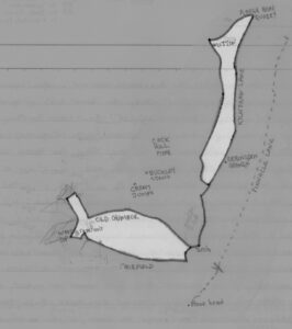
The customary final sign of the Zodiac, Pisces features the usual pair of fish, linked by a cord (represented by well-used tracks) between their mouths. They sport on the hillside to the south of Hebden Bridge, at 90o to each other, about 500 yards apart and 150ft in altitude between them; the upper faces NNE, the lower faces WNW. Equidistant in the angle between them is the farm known, appropriately, as Great Jumps, for the fish are configured as if leaping – the bottom half of the lower fish is submerged in woodland, but its upper half is breaking the surface into the air of the fields above, while the upper fish has its tail uppermost on the flank of the moor. From the opposite hillside, the upper fish is clear to see – not so the lower.
These two fish, then, seem to depict the typical traits of Pisces: exuberant or thoughtful, transparent or with hidden depths, conscious and subconscious, physical or spiritual. The landscape fish here mirror these traits, and are very different types; the upper fish is long and slender, built for leaping; the lower one is bulkier in shape, built for basking in reeds, that the tree trunks of its lower section call to mind. On each fish, the head, body and tail sections are separated by paths of field boundaries, a threefold division that reflects not just basic physical segments, but also the trident symbol of Pisces’ ruling planet, Neptune.
Our walk takes us from the shadows of the lower fish to the heights of its leaping companion, and back again. We start at the railway station, walking down the slope on the other side from the bus stops, turning right under the bridge and heading for the track that leads uphill to the left of the new(ish) houses. Above and to the right is Crow Nest Wood, and it is in this wood that the lower fish basks, its underside on a path a few yards above us. We meet the fish when the track bears sharply around to the right; you are now on the rear of its tailfin – the lower section is the small field to the right. A little up the track is a bungalow on the right, and in front of it an indicator of Pisces’ watery element, as a trickle of water emerges by the path. Just above is Wood Top; turn right in front of the old houses and you are walking on the division between top and bottom tailfins – note the house at the far end, with its 1657 datestone, its ‘witch pinnacles’ atop the gables, and if you look closely a small ‘archaic head’ squeezed into the gable top. Opposite is a well trough, as you emerge on to a small track and turn left past Wood Hey Lane – the field below this lane in the angle between it and the houses is the upper tail, but we keep on uphill on the setted track. This follows the back of the lower fish, now surfaced among the fields beside us.
A passing place on this slope affords a good chance to orient yourself to some of the other signs of the zodiac; perhaps you have followed each sign in its turn, and now you are at the final sign this is an opportunity to place yourself and the signs in the upper Calder valley landscape. Looking back down the way you have come, you can see Mytholmroyd, with the gash of Scout Rock above it, from where Sagittarius rides out to the south of the river. On the opposite side of the valley the two strips of woodland branching off from a narrow clough mark the wings of Libra. Scorpio, however, is unclear but lies between them, curling around the upper hillside towards Midgley. From this stopping place you can also see the tower of Heptonstall Church, where Leo stands, and perhaps you might reflect here on Pisces on the fish symbol of Christianity as you continue uphill, around and past the half-ruined barn with its impressive arch. This is the hamlet of Old Chamber, and here on the back of the fish, you are reminded again of the watery element of Pisces – a well, and a little gutter that accompanies you past the houses with a constant gurgle of running water.
At the end of the line of houses is a rebuilt (2007) listed farmhouse, The Lodge; the date of the original house, 1664, is remembered on a datestone on the porch, which is also decorated with hearts – look back and up as you pass the house and you will see another little ‘archaic head’ high in the gable, another way the rebuilder honoured local vernacular architecture traditions.
A little further is Old Chamber itself; the back of the fish drops away here down the track to the right, but keep to the left, past a little wooden shed called ‘The Honesty Box’. I hope it is open when you pass! This is a refreshment stop provided by local residents, and provides ice cream, cake, eggs and tea-making facilities for a small charge, or you can take shelter for free if the weather requires.
The track past the shed goes uphill, and allows some more perspective across the zodiac. Leo lies in Hebden Bridge below, its hind feet in Hepotonstall, and to the left of the village a line of houses in the middle distance marks the road which draws the keel of the Cancer ship. Following the drift of the track you are on, you come up to a T-junction and as you bear to the right you find yourself facing Stoodley Pike. Along this stretch you can orient yourself to more signs of the Zodiac – the Colden valley, with Gemini at its top end, and to its left the fields of Taurus. Straight in front of you, to the right of the path and the Pike, a rounded hill is the body of Aries.
At the next crossroads, a tarmac road comes up from the right, but you turn left, uphill, and you are walking along the ‘snout’ of the upper fish, along a deeply incised track. The fish lies to your right, occupying the steep slope above the lane below. Unfortunately, when you get to the top of the slope, which is a clear geographical feature marking out the fish form and enhanced by stone field walls you can glimpse through a fallen section of the track wall, there is no public right of way by which you can follow the fish’s back – proceed on the track past the exposed house of Rake Head with its almost-windowless west wall, until you come to a gate opening on to the open moor. Through the gate, turn right, and follow the track above the wall. This stretch is likely to be the muddiest and boggiest of the whole walk! It’s also on this stretch that if you are walking towards the end of Pisces you may well hear the voice of the curlew, a bird with one of the wateriest cries I know.
After a stretch, a broad track drops away to the right. Stop here. At the junction, a rickety stile crosses the wall on the right; the recommended route is down the broad track, but over the stile there is a walled track leading downhill, marking off the tail section of the fish. Halfway down, at the midpoint of the tail, a well-trough was marked on 1970s editions of the OS South Pennines map, in the same area as the well we passed on the tail of the lower fish. However, the well-trough is no longer, though it is possible to see where it would have been, on a peaty stream crossing down the field. If you keep on this track to the bottom, it will take you down a marvellous stone staircase to Kilnshaw Lane – but as I say, the recommended route is to follow the broad track from the moor junction, along the trailing edge of the trail, to get to the lane at the foot, and turn right to follow the underside of the leaping fish.
As you walk along Kilnshaw Lane, you pass Mitton, the white farmhouse of Kilnshaw, and just before the third house on the right the path demarcating the fish’s tail comes down its stairway to the lane. Continuing along the lane, the body of the fish is to the right, and you can see where the water running off down the slope pools in the fields at the bottom and nourishes the marsh grass. You come to Erringden Grange on the right, and just beyond you are walking on the underside of the head – you can see the track you climbed earlier on the far side of the field. A wall has been removed in this field, leaving two gateposts standing alone, a reminder of the duality of Pisces.
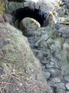
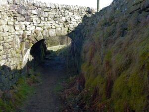
At the gate and crossroads, go straight across, and you are back on the cord between the fishes. Follow the track downhill, but when you come to the crossroads near the electricity pylon, go straight across (unless you want to visit The Honesty Box, 100 yards or so down the track to the right). The steepish path downhill is gullied, and needs care, but it leads you to the most remarkable feature of Pisces; a tunnel where another track has been built across as a flyover. This tunnel is at a potent location – it is where you enter the lower fish, the one that swims half-submerged in the woodland below. You enter it through this deep path and damp tunnel, like a dripping cave – a very Piscean experience…It is like an initiation portal, whichever direction you come at it from – if you are approaching from the lower fish, the path up into the field zone parallels an emergence from the underworld.


Out the other side, the path is even more gullied since the Calder Valley floods on 2012 and 2015, and needs extreme care, but the deep channel in which you are forced to walk seems to enhance the sense of going down into the submerged part of the fish – which you reach at the trees, at the centre of the mouth, and your route bears down the holloway to your left to the bottom where the path bears round to the right. Follow this track along the bottom of the woodland, aware that you are also following the underside of the fish; just over halfway down you will see a path branching to your right back up through the woodland – this track continues the fish’s belly up towards Wood Top, but you keep on the path you are following to come out just above the rail station.