The first sign of the Hebden Bridge Zodiac to be found was Sagittarius (Nov. 22-Dec.21 approx.), so our series of self-guided walks begins with this sign.
You’ll need the Ordnance Survey 1:25000 South Pennines map. Please note that routes and their condition were accurate at their time of survey, 2018-2020; updates may be made at later dates.
Please be alert to any other quasi-affirmations of Sagittarius as you walk!
Out of the wound-gash in the earth, the horseman mounts, shaking his plumes clear of dark soil.
Out of the blood-dark womb gallops bowed the horseman of iron.
The blood-crossed knight, the Holy Warrior, hooded with iron, the seraph of the bleak edge,
Gallops along the world’s ridge in moonlight…
These lines from Ted Hughes’ poem, Gog, seem to describe the figure of Sagittarius, the mounted archer, as he rides along the stony crag of Scout Rock in Mytholmroyd. From Hughes’ birthplace in Aspinall Street on the N side of the village, for three years or so he looked out on Scout Rock on the other side of the valley, “the memento mundi over my birth”. He didn’t like it[1] – its presence was overpowering. In those days of the early 1930s, there was far less tree cover, and the crag, a scar left by an ancient landslip, was a dark cliff imposing its shadow across the village.
 Scout Rock in the early 20th century
Near Hughes’ birthplace, on Midgley Road, is an old pub. It is now a private residence, but still bears the name of the inn – The Huntsman. Above Scout Rock, on the hills of old Sowerby township, cluster several legends of Robin Hood – a standing stone at which he used to pitch quoits; a spot where he was digging and threw two enormous stones clear across the valley, one to land near Wainstalls and the other on Midgley Moor, and each known as Robin Hood’s Pennystone after a bygone quoits-like pastime; and a little way up Cragg Vale, Robin Hood Rocks. Robin Hood is not remembered around here as an outlaw of the greenwood, but as a man of the land and the stone. Robin Hood, The Huntsman, the Sagittarian rider with his bow – all seem to allude to this great figure overstriding Mytholmroyd. Other terrestrial zodiacs in the UK, such as Glastonbury, similarly allude to a local hero figure, often, unsurprisingly, to King Arthur, with the zodiac as his ‘Round Table’; however, given Robin Hood’s greater presence in the Pennines, he is surely more appropriate to the Hebden Bridge Zodiac, and also appears in Mary Caine’s Sagittarius in her Kingston-on-Thames zodiac.
 Robin Hood Rocks, Cragg Vale
Sagittarius was the first figure of the local zodiac to appear, in 1976. One night, a friend and I were walking along Heights Road, above Mytholmroyd, looking down on the lights of the village, and found that we each had seen, or imagined, a great mounted figure firing an arrow, outlined in the streetlights below. The only difference was the direction we saw the arrow heading; my friend, poet Michael Haslam, saw the fiery orange arrow soar up Cragg Vale, while I saw it arc along the valley towards Hebden Bridge. Perhaps we both saw a “bow of burning gold”, and our “arrows of desire”! A year or so later, I applied this circumstantial vision to the map – and found that the streetlights did indeed give a clue to a mounted rider in the landscape.
Sagittarius can be a centaur, half-human and half-horse, or a mounted archer, as here. The fusion between human and horse is implied in either guise. Astrologically it expresses higher learning and new thought and projects, and it is associated with travel (the train station stands at the horse’s heart), sport (playing fields can be found around both the fore and hind legs) and outdoor pursuits. Inspiration and synthesis are among its characteristics, reflected by its role in the genesis of the Hebden Bridge Zodiac, as well as in its business history, which includes a company internationally known for riding gear (Caldene), another that was Britain’s premier blanket firm (Moderna), pioneering egg production (Thornber) and highly successful coin counterfeiting.
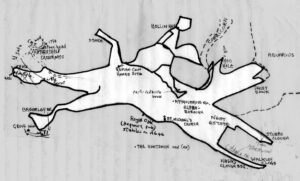
The body of the horse lies squarely on Mytholmroyd north of the river – the church of St Michael’s (not a saint, but a Hero/Warrior archangel appropriate to our Sagittarian rider) sits at the centre of the belly line, drawn by the River Calder. Its front legs, stretched in full gallop westwards, terminate at Stubbs Clough and the old mill that housed Walkley’s Clogs, Britain’s last significant clog-making factory. Its rear legs kick up behind, one kicking at Brearley Bridge, the other at the parish boundary on the hillside at Hathershelf. Its head is lifted to the hills up Daisy Bank, its ear in the valley at Hoo Hole. Between the head and the rider, beside Cragg Brook, lies the bow. The rider sits astride the horse by Scout Rock, his hooded head facing up the valley where the arrow flies westward. The arrow is directed perhaps at the centre of the zodiac in Hebden Bridge, but is better seen as directed at Sagittarius’ opposite number in the zodiac, the kneeling giant of Gemini 3½ miles away in Blackshaw – the giant kneels, flexing his muscles, staring back at the rider and opening his chest to take the arrow. Thus, the arrow becomes the axis of Calderdale’s terrestrial zodiac. From muzzle tip to hindermost hoof, the figure is just short of 1½ mls – be prepared for a longish walk with a number of slopes… And a muddy walk in places, I regret to say.
The walk starts in Brearley, beside the main road, easily accessible by bus. If you are car-bound, however, there are few parking opportunities in Brearley, and I would recommend parking in Mytholmroyd and walking along the Rochdale Canal towpath. You will see the imposing Brearley Baptist Chapel across to your right on the other side of the river, and you leave the towpath at the next bridge. Follow the road down past the houses and round to the right, over the river, and turn right just past the bridge, towards the chapel, and you are on the horse’s lower hind leg, outlined by the river and this path. The lane bears left at the end, labelled the Calder Valley Greenway, and crosses the railway. Just before the bridge is a sculpture, one of Mike Williams’ Millennium Sculptures of 2000. It’s a little macabre – facing you is a skeleton, and below that an inscription relating to a murder, and a design known to history as that on a Portuguese gold moidore, in common currency across Europe in the 18th century. On another face of the stone is a pair of metal shears. Together, these images reveal the sculpture to relate to the Cragg Vale Coiners, a gang of counterfeiters that were active in a big way in the Calder Valley economy of the 1760s. The murder referred to is that of the Government exciseman, William Deighton, assassinated by gang members near his house in Halifax in 1769.

The Greenway path veers off to the right after a hundred yards or so, but the Sagittarius horse’s leg takes a left fork by the signpost, passing to the left of a gully. This path is a little overgrown, but clear to follow, and eventually the wall to the left does a right-angle turn uphill. Our path continues straight on, but just at this point things often get very soggy and muddy; find a way around it, heading for Scout Bottom farm, go through the gate marked with the yellow footpath arrow, and cross in front of the house. Still walking on the hindleg, follow the track through to Scout Road, and turn left.
The path enters a walled track and continues behind Great Scout Farm; through a line of planted conifers, angle up towards Little Scout Farm, and pass through a gate in front of the buildings. On the far side of the houses you’ll see a line of steps climbing up beside the wall, and up you go – but take care to go through the gap half-way up, and resume the climb on the opposite side of the wall, keeping the wall to your left, towards the gate at the top, which takes you on to the Scout Road. Turn right and in a few yards you will see a footpath striking off to the left, above the tree-line.
As you climb Scout Road, note the woodland on your right, and above it the scar of Hathershelf Scout – Scout Rock, or simply ‘The Rock’. The tumble of rocks gives a clue to the background of this area, which was caused by a landslip at some unknown time in the far past. Around 1952, men out rabbiting were led by their dog to discover a cache of Roman coins somewhere in this wood. Not all of them made it to official locations, and I have no idea if any of them are in public hands today. Nearby, a council rubbish tip was located in this woodland, but in the 1980s it was found to contain dangerous blue asbestos, probably from Old Town’s infamous Acre Mill. Some of this had decayed and spread across the land on the neighbouring hillside – reparatory work was set in motion in the 1990s, and people were discouraged from walking and playing in the wood in case they disturbed stray asbestos fibres. The tip is now safely covered over, and the cautionary signs removed from the wood, so hopefully the risks have been dealt with. In passing, we might note that the estimated site of the Roman coin hoard shown on 1970s OS maps approximates to the horse’s anus – oddly, in a link that is curiously ironic at least, a hoard was also recovered in a similar part of the horse’s anatomy in the Sagittarius of the Cuffley Zodiac, identified in the 1970s.
As you come clear of the woodland, a footpath cuts sharply back on the right, and takes you above the trees and above the scar, passing through the upper hindleg of the horse. Where the trees fall away to the right, the path begins to draw the hindquarters as it approaches the top of Scout Rock.
Look out across the valley from here. If you have done the Scorpio walk you will be able to recognise Calder High School and the line of Midgley Road leading up to the village itself, and the curve of Thorney Lane as it turns into the Luddenden Valley to mark out the sinuous shape of the scorpion’s body. Directly across the hill, the slope between the moors and the hillside Heights Road are Scorpio’s body. Down near the school, the old Huntsman Inn gazes up at you as you ride here the back of Mytholmroyd’s great horse.
Keep following the path above the trees, with a view over Mytholmroyd “from the other end of the telescope, as it were”.[2] At the high point, a longish narrow field standing perpendicular to the path on the left may be construed as the horse’s tail, and shortly after, as the path curves away to the left, away from the trees, you are entering on the line of the hooded and cloaked rider’s back. You will see a beacon firepan near the path; a notice records that it was donated by the Hebden Bridge Round Table, an ironic echo of a metaphor expressed by many astrologers that the wheel of the zodiac is a ’round table’, with all the implications of Arthurian romance. The path takes you round the hillside, and you are looking down now on the northern extension of Mytholmroyd into the Cragg Vale valley. In the fields below you will see lines of long low sheds, readily recognisable as one-time sheds for battery-hen farms, but now refunctioned as a range of business premises.
All across the hills to our left now are the sites of Robin Hood folklore already mentioned, and Robin Hood Rocks is a mile in front of us. Our path comes out above a fine broad paved track, Hall Bank Lane, an old holloway. If you fancy a sit-down to enjoy the scenery, there’s a bench on the far side of the track; when you’re ready, descend the paved track. I find this old route very atmospheric and evocative of what I might call neo-mediaeval thoughts! Especially in the tunnel of holly trees. As you go through, look at the paving on the left of the track, and you will see a short section of rut made by the wheels of carts. A little further down, a public footpath leads off to the left; Hall Bank Lane proceeds downhill to mark the belt at the waist of the rider (there’s even a wider section suggesting a pouch on the belt), but you go through the stile and tend downhill as the path follows the rider’s back. The land above the track, especially if you follow the yellow arrows towards the stone hut, is often waterlogged, so bear downhill towards the farm. A long rectangular field to your right suggests a quiver for his arrows. In due course you will come into a walled track which leads you to Little Hollin Hey. Here, a square field juts out below the barn conversion, to the left of the track – this is the rider’s hooded head, and the track we walk on past the house and down to the right marks the clasp at the neck of his cloak.
Walking down from here we are following the rider’s chest line. We pass a track that cuts back on the left towards Hollin Hey farm – security notices warn us off, suggesting something here bis considered of value (perhaps only privacy), but at one time it would seem to have been an important property – The Rev. John Watson, the celebrated 18th-century Halifax antiquarian, noted that at Hollin Hey “it is said a court used to be held, and the owner of it bound to keep a white bull, a stoned horse [ungelded stallion], and a brawn [pig]”.[3] This private track down past the farm towards the trees marks the top of the rider’s sleeve. You continue down to where the road meets the foot of the old paved Hall Bank Lane that you left earlier for it to mark the belt at the rider’s waist; so from here you are following the front of the rider’s leg down into the village.
Just past this junction is a stile on the left, which leads on to a path marking the rider’s lower sleeve; it would take you down past the battery sheds you looked down on earlier, and whether we like it or not there is something Sagittarian about these. These were at one time Thornber’s egg farms, foiunded in 1907 as the first and biggest of several such farms in the valley, and also pioneers of this style of farming in the country in general! As a business it may have been ethically distasteful , but as a business model and initiative it struck new ground, a classic application of Sagittarian values.
Nonetheless, stay on the road between high hedges – like the old paved track, this is an old holloway. You will come to New Delight, and just beyond it redbrick outbuildings, and just beyond them New House, dating from around 1718, with its fine two-storey porch. Around 1770, this was the home of one of the Cragg Vale Coiners, Thomas Spencer, brother-in-law to the gang-leader, David Hartley; in 1783, Spencer and an accomplice, at a time when grain prices were too high for many poor people, forced several dealers to sell their grain at the ‘old prices’ to the poor in the Halifax Corn Riot. For this Robin Hood-like act, they were both hanged and suspended in chains on Halifax’s Beacon Hill.
On the final stretch of this slope, coming to the old Scout Road Methodist Church, you are at the rider’s ankle – his foot is off to the left, with King Street and Queen Street appearing like stirrup straps. The sole of his foot, suitably for its linguistic ‘echo’ rather than its etymology,[4] is marked by Stubbings Street.
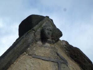
At the junction, 17th-century Mytholmroyd Farm faces you. Notice some interesting architectural details – in one gable, a small carved head has been nicknamed ‘the witch of Scout Road’, and is an example of a traditional ‘charm’ to protect the house.[5] On the window drip-mouldings on the side of the house are two types of decoration – but they are decorative with a function similar to the head. There are lozenge shapes with a boss in the centre – these represent eyes, and are intended to deflect the evil eye. There are also horizontal heart shapes, at one time known as ‘devil’s arrows’ and also aimed at warding off any kind of devilment.
Turn left towards the village, and at the next junction turn left, away from the village. As you walk along this stretch of Cragg Road, it forms the front of the rider’s bow, directed westwards; the bowstring is the quivering brook that runs alongside the road, giving the impression of an arrow just released. Follow the road up past the semis on the right and the industrial buildings on the left till you get to a footpath running uphill to the right, to Hoo Hole. Hoo Hole House stands on the horse’s ear, and appropriately enough is recorded in history as a place where John Wesley preached in 1770 to an attentive crowd, two months to the day after the execution of the leading Coiners David Hartley and James Oldfield – perhaps provocatively, his topic was, it is said, ‘render unto Caesar that which is Caesar’s…’. He survived, however, and the remnants of the tree under which he spoke are preserved in the garden of the house.
The horse’s head lies in the fields to the right as you pass through Hoo Hole Farm, climb the slope, and you step foot on it at the T-junction of paths at the top of the slope. Bear left, and you are on the nose as you pass Hollock Lee; follow the track round to the right, and very soon follow the curve into the wood, rather than follow the track itself. This draws the muzzle of the horse as it rushes headlong along the valley, tossing its head up to Daisy Bank. The path takes you to the lip of the hill and brings you to a gate and immediately after a stile to a path taking you straight downhill, along the horse’s neck.
You emerge from the path on to Stocks Lane – diagonally to the right, in a garden at the road junction, is a stone replica of a set of stocks, in what were once the grounds of Stocks Hall. You turn left, keeping Nest housing estate on the right, and passing Nest Cottage – where the Aquarius wing drops down from the moor to tap Sagittarius – on the left; at the end of the redbrick houses come to Buckley Gate, with the enigmatic inscription on its corner, ‘ALL RIGHT’. You take the left, though, down Roger Gate, signposted towards Stubb, and it is to there that you direct your steps along the top of the horse’s upper foreleg; on your right are playing fields, a counterpart in the Sagittarian love of sport to the cricket field and football pitches close to the hindlegs.
The horse stubs its hoof at Stubb Clough, but the track takes you down to Great and Little Stubb at its knee. Where you see two footpath signs, you follow the one pointing left, in front of the terrace of houses, and beyond them down a shady track which brings you to and under the railway line – it’s interesting that the Sagittarian horse is the only sign in which Calderdale’s Iron Horse passes through the figure itself. Bear right and Stubb Clough joins you as you follow the track down to a cluster of industrial buildings and a highways depot. Here, you are on the lower foreleg, which terminates to your left, its hoof at the bridge by which once stood – again, appropriately – the mill which once housed Britain’s last major clog factory, Walkley Clogs (formerly Maude’s Clogs until 1946) before becoming a popular crafts and entertainment emporium through the 1980s and 1990s. The historic mill was burnt down in 2019.
But you turn to your right, and follow the track past 17th-century Hawks Clough Farm to your left and out on to Caldene Avenue, which you follow back into Mytholmroyd and the heart of the village, with the station, New Road, and shops mostly located around the very heart of the horse, and St Michael’s Church in its belly.
First published here Dec. 30, 2023. Please refer back to main article: https://northernearth.co.uk/walking-myth-into-place-the-damned-zodiac/
[1] “From my home near the bottom of the south-facing slope of the valley, that cliff was both the curtain and back-drop to existence. All that happened, happened against it or under its supervision…” Ted Hughes, ‘The Rock’, from Worlds, Seven Modern Poets: Penguin, 1974, pp.122-124
[2] Ted Hughes, ‘The Rock’
[3] Watson
[4] ‘Stubb’, ‘Stubbing’, etc. place-names in the everyday world generally refer to areas of tree stumps, i.e. partially cleared land.
[5] See John Billingsley, Stony Gaze, Capall Bann 1998.